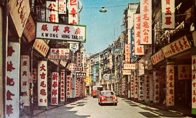
This surprisingly, for Hong Kong, underpopulated street scene, is interesting, all the same, for its commonplace depiction of a taxi and a bus passing under a centrally placed suspended street lamp and between a riot of colourful shop signs. The image is rather too generically labelled “West Point”, but I am more than hopeful that one or more Gwulo Colleagues will be able to identify the precise name of the street shown in this iconic 1967 West Point scene.
The image appears in the 1968 edition of the Official Guide Book of the Hongkong Hotels Association, as published by A-O-A, 1302 Manson House, Kowloon.
As per Colleague "moddsey"'s illuminating submission in Comments below one now knows the identity of the photographer; the original photo title; and a probable date:
The photograph also came as a postcard: Colour photograph by K. P. Yuen with title "Queen's Road Central'. Earliest seen is a dated postcard from 1964, writes Colleague "moddsey".
Comments
Queen's Road Central
Thanks for posting. It's such a lovely photo it would be well worth the effort of trying to identify its exact location.
The best way of doing so would be to match the names on the signs to old businesses with confirmed addresses, but the only sign I can read is “Kwong Hing Tailor”.
Googling “Kwong Hing Tailor Hong Kong” got a hit on a shop of the same name at 117 Queens Road Central. That’s not far from the “West Point” in the title of the photo, so I initially thought they might be one and the same. Unfortunately, although their names in English are identical, their names in Chinese are different by one character, so I suppose there’s no connection between them.
An image search revealed the following.
So the subject photo is probably of QRC, but where exactly? It shows traffic flowing in one direction only. If back in the 60’s, as now, QRC traffic flowed from east to west then the camera must have been pointing in an easterly direction - towards Central.
Other obvious features in the subject pic are;
Searching the 1967 survey sheets (map ref. 1967.2 on www.hkmaps.com) for a stretch of QRC matching all these features reveals this section as the closest fit.
It’s in Sheung Wan within the section between Hillier Street and Bonham Strand. I reckon the photographer was standing on the pavement at about No. 241 or 243 QRC facing towards Central. The red camera icon and lines mark the approximate position of the camera and limits of the subject photo respectively. Kwong Hing Tailor would have been at about 237 or 239 QRC.
Corrections welcome, particularly if someone would be kind enough to match a sign in the photo to an address.
Thank you Colleague “gw”
Thank you Colleague “gw” for your interest and research. Like for you, there is much in that image that catches my attention. I see that homophone for the tailoring establishment you mention, and agree with your rejection of it as a serious possibility. I really enjoyed reading your thorough research on the possible location of the image, and now feel pretty confident in putting Queen’s Road Central in the image title. Thanks for that.
Re Photo
Thanks to "gw" for taking the lead in identifying the section of Queen's Road Central (QRC) that the photo was taken.
Yes, the bend is the Sheung Wan section of QRC near Mercer Street.
The view in the opposite direction can be seen below. A vertical signboard (partially obscured) below of an ivory factory/shop can also be seen in “Old Hong Kong Seen Through Lens of Francis Wu” (Old Hong Kong seen through lens of Francis Wu | South China Morning Post ), photo Number 2 in the series. Near to this signboard was the Man Hing Ivory Factory which was located at 215 QRC.
A long view of the stretch of QRC between Mercer and Hillier Streets. Kwong Hing and Kin Ngai Tailor Shops below.
With reference to the main photo in the Hotel Guidebook, the photograph also came as a postcard: Colour photograph by K. P. Yuen with title "Queen's Road Central'. Earliest seen is a dated postcard from 1964.