HK Waterworks Principal Supply Network in Mid Sixties, by WYIP
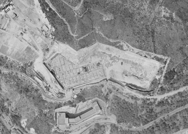
This Hong Kong freshwater supply network map was found in the 1965-66 Hong Kong Annual Reports revealing the vast network of freshwater pipes connecting various reservoirs in Hong Kong in the mid-sixties. The service reservoir on Mount Davis was part of this effort and is mainly used to distribute water from Shek Pik Reservoir in Lantau Island to the freshwater networks in Hong Kong. Long water pipes were built to transfer fresh water from Shek Pik Reservoir to Silver Mine Bay and from there, through a long undersea pipe to the pumping station in Hong Kong Island’s Sandy Bay. Water was then pumped uphill to the Mount Davis Service Reservoir located in the midsection (elevation-wise) of Mount Davis. From there, water gravitates to all parts of Hong Kong and Kowloon. So, this service reservoir is essentially a staging storage area for fresh water fed from the Shek Pik Reservoir.This service reservoir is actually not a “reservoir” in the traditional sense. It consists of several large water tanks buried in the hillside of Mount Davis. Construction began in 1963 right after the Shek Pik Reservoir was completed and became operational in 1966. The top of this service reservoir is a large piece of flat grassland. According to other HK Government documents, this service reservoir was sized for 30 million gallons. This large piece of grassland is accessible through a service road from Mount Davis Road. I was there a couple of times while I was hiking along Mount Davis Road in the late sixties and early seventies. Back then, I was unable to figure out what it was for. Looking south from this vantage point, one could see as far as the Wah Fu estate and Lamma Island. I guess this breathtaking view is no longer there as all the residential high rises built along Victoria Road and around the Cyberport area have blocked this scenic view.
The lawn is very untidy now as the Water Department did not tend for it. However the view is still stunning. The view towards Lamma Island, Cheung Chau & Lantau is generally NOT obscured when I went there a few months ago At least not yet.
Thanks for the correction. Come to think of it, Lamma Island is further to the west side and so it is not likely to have been blocked by high rises in the Sandy Bay area or around the Cyberport area. I almost forgot to mention the majestic High West on the east side. The view during sunset was just unforgettable.
Hong Kong Waterworks Sandy Bay Pumping Station 1964, by WYIP
This photo is from Google Earth showing the Hong Kong Waterworks Sandy Bay Pumping Station. This station pumps fresh water from Shek Pik Reservoir uphill to the Mount Davis Service Reservoir.
Close-up view of the Hong Kong Waterworks Sandy Bay Pumping Station. This is also from Google Earth. The year “1964” was also labeled on the wall, indicating that it became operational in 1964. This pumping station receives fresh water from Shek Pik reservoir via a long water pipe and pumps water uphill to the Mount Davis Service Reservoir
Thank you for sharing this fascinating information and photos of the pumping station. I never realized the reservoir played such an important role in the island's water supply and the extensive network required for it to reach Mount Davis. No wonder all those rectangular compartments appeared in the aerial photo, and it now makes so much sense that they were built as individual water tanks!
Comments
The Role of Mount Davis Service Reservoir
This Hong Kong freshwater supply network map was found in the 1965-66 Hong Kong Annual Reports revealing the vast network of freshwater pipes connecting various reservoirs in Hong Kong in the mid-sixties. The service reservoir on Mount Davis was part of this effort and is mainly used to distribute water from Shek Pik Reservoir in Lantau Island to the freshwater networks in Hong Kong. Long water pipes were built to transfer fresh water from Shek Pik Reservoir to Silver Mine Bay and from there, through a long undersea pipe to the pumping station in Hong Kong Island’s Sandy Bay. Water was then pumped uphill to the Mount Davis Service Reservoir located in the midsection (elevation-wise) of Mount Davis. From there, water gravitates to all parts of Hong Kong and Kowloon. So, this service reservoir is essentially a staging storage area for fresh water fed from the Shek Pik Reservoir. This service reservoir is actually not a “reservoir” in the traditional sense. It consists of several large water tanks buried in the hillside of Mount Davis. Construction began in 1963 right after the Shek Pik Reservoir was completed and became operational in 1966. The top of this service reservoir is a large piece of flat grassland. According to other HK Government documents, this service reservoir was sized for 30 million gallons. This large piece of grassland is accessible through a service road from Mount Davis Road. I was there a couple of times while I was hiking along Mount Davis Road in the late sixties and early seventies. Back then, I was unable to figure out what it was for. Looking south from this vantage point, one could see as far as the Wah Fu estate and Lamma Island. I guess this breathtaking view is no longer there as all the residential high rises built along Victoria Road and around the Cyberport area have blocked this scenic view.
Re: view from the service reservoir
Hi There,
The lawn is very untidy now as the Water Department did not tend for it. However the view is still stunning. The view towards Lamma Island, Cheung Chau & Lantau is generally NOT obscured when I went there a few months ago At least not yet.
T
Thanks
Thanks for the correction. Come to think of it, Lamma Island is further to the west side and so it is not likely to have been blocked by high rises in the Sandy Bay area or around the Cyberport area. I almost forgot to mention the majestic High West on the east side. The view during sunset was just unforgettable.
Sandy Bay Pump Station
This photo is from Google Earth showing the Hong Kong Waterworks Sandy Bay Pumping Station. This station pumps fresh water from Shek Pik Reservoir uphill to the Mount Davis Service Reservoir.
Sandy Bay Pumping Station Closeup
Close-up view of the Hong Kong Waterworks Sandy Bay Pumping Station. This is also from Google Earth. The year “1964” was also labeled on the wall, indicating that it became operational in 1964. This pumping station receives fresh water from Shek Pik reservoir via a long water pipe and pumps water uphill to the Mount Davis Service Reservoir
Reservoir's Role
Thank you for sharing this fascinating information and photos of the pumping station. I never realized the reservoir played such an important role in the island's water supply and the extensive network required for it to reach Mount Davis. No wonder all those rectangular compartments appeared in the aerial photo, and it now makes so much sense that they were built as individual water tanks!
Background History of Mount Davis SR
Glad to learn that there are other Gwulo readers also interested in this little-known background of the Mount Davis Service Reservoir.