The camp was built in this isolated and idyllic bay, now called Siu Sai Wan, in the very early 1950s. In 1957/8, getting there from our usual pick-up stops in Causeway Bay or North Point took well over half an hour in one of the R.A.F.'s 3 ton Bedford trucks. These were roofed over with a canvas cover and with wooden benches along either side, so anyone suffereing from travel sickness would have had a hard time The roads were practically empty and the 'gharries' usually had a clear and fast run. Only the hill out of Shau Kei Wan slowed us down. The narrow Cape Collinson Road and then the very steep and even narrower camp road (now a lovely path) down to the camp seemed to be a challenge to our drivers to better their previous times.
Date picture taken
1958
Gallery
Shows place(s)
Comments
The old camp road
I walked up the path that was the old camp road for the first time earlier this year. There were a couple of places where it looked as though there were the old Japanese wartime tunnels dug into the banks of the road. I wondered if there were any tunnels around when you were there in the 1950s, and if there were any stories attached to what they were there for.
Regards, David
David,
David,
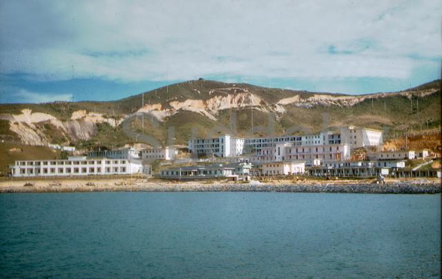
Yes there was one very short tunnel (about 12 ft long) that I explored in 1958. It left the road at the point where it is closest to the ridge line and opened up to a 'viewing' window overlooking the sea. I took two monochrome photographws from there, one of the lighthouse and one looking the other way. A steel girder holding up the roof was made by Dorman and Long of Middlesborough, UK., which made us think, wrongly, that the tunnel was British. I suspect that as the tunnel was not far below the surface it was a cut and cover one. While there, some of the Chinese contractors infilling the bay arrived and I got the impression that they were talking about clearing the tunnel which was looking a bit dodgy. I found the remains of it some time around 2004 - just a short cutting to the cliff face. I believe that there is a small sign warning you to be careful. People obviously still climbed up and down the cliff there because there was a thick rope going down to the sea. I guess that people fishing used it. One of my pals remembers exploring a much longer tunnel that was probably somewhere below the highest part of the ridge above where they were excavating the hillside for earth to infill the bay. If you look long enough at the colour photograph that I took of the camp from the sea, you could almost persuade yourself that there are one or two tunnel entrances just above the largest part of the excavations. Since 1958, more of that hillside has been removed and in recent years stabilised with concrete to prevent further erosion, so I suspect that those tunnels no longer exist. I have no knowlege of any tunnels right next to the road - we'd have seen them as we did the one that I entered, but there are several square-shaped drainage 'tanks' roughly a cubic yard in size that were there in 1958.
Andrew
Thanks Andrew. I think it's
Thanks Andrew. I think it's the cutting I remember, rather than full-on tunnels. I thought I'd taken a photo, but can't find it now!
Interesting to hear about the larger tunnel that used to be in the area. As the hillside overlooks the entrance to the harbour, it seemed a natural area for there to be Japanese tunnels.
Regards, David
Cutting off Little Sai Wan Camp Road
Here's the former tunnel/cave, now a cutting, discussed above.
The sign board at the far end warns of the steep drop down the cliffs just beyond it. The beam running across the top of the cutting is made of concrete and stone and is actually an open topped water channel. Here's a close up.