Ewo Mess has been added as a "place" in this photo, but I don't think it can be seen. The white building seen in part on the left edge of the photo is Edgehill. Ewo Mess was the next property further up Mt Austin Road above Edgehill, i.e. out of sight to the left.
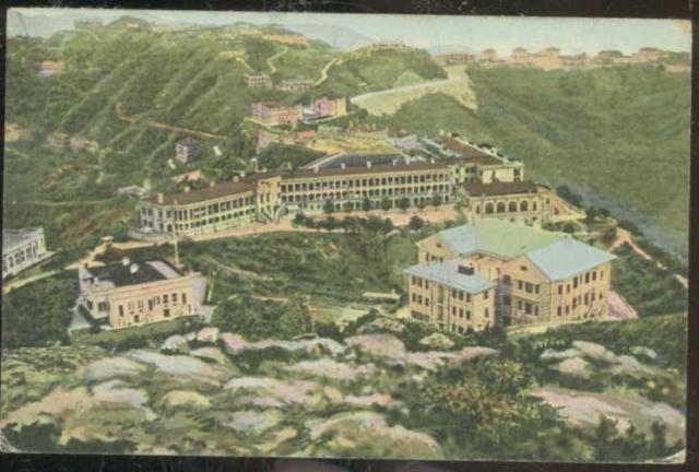
Look at the ridgeline at the top of the photo. A light-coloured road (Chamberlain/Stubbs Road) reaches the ridge just below a long, flat-topped building. To its right are taller houses with dark coloured roofs. Together these buildings formed "The Homestead" - civil servant quarters consisting of one block of flats (the long, flat-topped building) and houses.
This 1945 photo was taken from almost exactly the same position as our pic and gives a clearer view of "The Homestead" buildings.
The 1945 photo shows that the roofs of "The Homestead" block of flats and its nearest house are on approximately the same level, but in our photo the top of the block of flats is lower, suggesting that it is incomplete and the roof is missing.
The PWD Reports contain relevant information on the construction of "The Homestead". The 1922 Report tells us, "By year end two houses were roofed and the other two were nearing roofing, whilst the block of flats had reached 2/F level". The 1923 Report states that three of the houses were completed in July, the fourth in September and the block of flats towards the end of November.
Our photo appears to show the block of flats without a roof, but at least three of the houses with their roofs on. Interpreting the PWD Reports, this stage of development must have been reached in early 1923.
Therefore, the photo was taken in 1923. One hundred years ago!
Comments
Ewo Mess?
Ewo Mess has been added as a "place" in this photo, but I don't think it can be seen. The white building seen in part on the left edge of the photo is Edgehill. Ewo Mess was the next property further up Mt Austin Road above Edgehill, i.e. out of sight to the left.
Agree. Removed.
Agree. Removed.
Centurian
Look at the ridgeline at the top of the photo. A light-coloured road (Chamberlain/Stubbs Road) reaches the ridge just below a long, flat-topped building. To its right are taller houses with dark coloured roofs. Together these buildings formed "The Homestead" - civil servant quarters consisting of one block of flats (the long, flat-topped building) and houses.
This 1945 photo was taken from almost exactly the same position as our pic and gives a clearer view of "The Homestead" buildings.
The 1945 photo shows that the roofs of "The Homestead" block of flats and its nearest house are on approximately the same level, but in our photo the top of the block of flats is lower, suggesting that it is incomplete and the roof is missing.
The PWD Reports contain relevant information on the construction of "The Homestead". The 1922 Report tells us, "By year end two houses were roofed and the other two were nearing roofing, whilst the block of flats had reached 2/F level". The 1923 Report states that three of the houses were completed in July, the fourth in September and the block of flats towards the end of November.
Our photo appears to show the block of flats without a roof, but at least three of the houses with their roofs on. Interpreting the PWD Reports, this stage of development must have been reached in early 1923.
Therefore, the photo was taken in 1923. One hundred years ago!